Latest News
The final study executive summary documentation is now available:
West Plains Subarea Transportation Management Plan, Phase 1, US 2 Vicinity Executive Summary Document [PDF 26 MB]
Phase 2 of the study, focusing on the I-90 vicinity of the West Plains, has begun and is being led by S3R3 Solutions (West Plains Public Development Authority). Please visit the West Plains Connection website for more information and ways to be involved with the study.
Study Overview
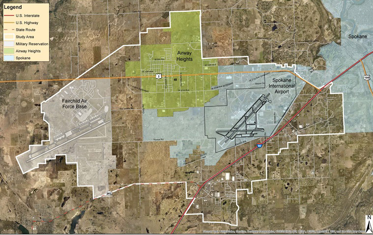
The West Plains Subarea Transportation Management Plan Phase 1, US 2 Vicinity, focuses on land use and multimodal transportation in and around the US 2 corridor west of I-90 between the Fairchild Air Force Base entrance at Mitchell Street to the west to just east of Russell Road (see the study area map below).
The study was led by Washington State Department of Transportation (WSDOT) Eastern Region Planning in coordination and collaboration with the various jurisdictional partner agencies in the study area (see the Contact / About Us page for more info on the study partners). As a “living study”, this website will periodically be updated with current information as it becomes available, to reflect changes in the study area including strategy implementation, land use development and other relevant information.
Purpose
Previous transportation studies have identified increasing mobility challenges along with increasing crashes around the US 2 corridor. The studies generally proposed a need to develop a transportation network for all users. This study’s purpose is to build upon the past studies and develop multimodal practical solutions to mitigate consistently increasing land use growth in the West Plains vicinity of Spokane County by achieving three primary objectives:
- Evaluate, refine, and align outcomes identified in previous planning studies and comprehensives plans,
- Evaluate current and projected future land use and transportation conditions, and
- Propose multimodal “practical solution” strategies that will provide for the evolving transportation needs
The study’s purpose and need statement, developed in collaboration with our regional partners, provides more information on the purpose of the study:
West Plains Subarea Transportation Management Plan – Phase 1, US 2 Vicinity “Purpose and Need” (PDF 646 KB)
Location
The map below illustrates the study area boundary and study corridor limits. Select the map to download a PDF copy (3.6 MB).